Planning on walking the Pyrenees Trail GR10 and looking for a good hiking-guidebook? Say hello to the 2nd edition of my popular e-book about this extraordinary long-distance trail in the French Pyrenees. It is the most detailed and comprehensive hiking-guide you can find about the GR10.
Fully updated and revised, my book now also contains detailed information for hikers with dogs. The 2nd edition was released in November 2025.
Fully updated and revised 2nd edition of The Pyrenees Trail GR10

Based on my second thruhike of the Pyrenees Trail GR10 in the summer of 2023, and also incorporating any and all new information I received since then, I published the completely updated and revised 2nd edition of my English guidebook “The Pyrenees Trail GR10 – Stage by Stage from the Atlantic to the Mediterranean” in November 2025. You can find it as e-book on Amazon by searching for the ISBN number 978-3982411613 or with the search term combination “gören pyrenees” (without the quotes).
Important note regarding Amazon’s “Read Sample” feature
Please be aware that all texts and graphics in the book are in professional, crisp quality, of high resolution and of the best legibility when you download it to your Kindle-app on your smartphone. The terrible quality of Amazon’s “Read Sample” on their shop-website does neither do any justice to my e-book, nor does it in any way or manner correspond to my book’s high-quality contents and layout.
Since the release of this 2nd edition, I have asked Amazon KDP-support countless times to correct the poor-quality “Read Sample” that they put under my book in the Amazon shop. Alas, they keep sending me automated replies saying that they are working on solving what they claim to be a technical problem. At the time of this blogpost, unfortunately nothing has been corrected yet. I believe it is rather a matter of incompetence on the part of Amazon KDP instead of a technical problem, because for the 1st edition of my book their “Read Sample” was of perfect quality.
That’s why I decided to post my own read-sample below, containing about 1/3 of the book’s pages, with samples from all chapters. Scroll up/down with the mousewheel or the arrows in the viewer-menu shown, zoom within any page using +/- symbols in the viewer-menu.
See my Instagram-reel showing how to navigate through my book in the Kindle-app
I have also made a short Instagram-reel with a video showing how the various features of the book work in the Amazon Kindle-app (you do not need an Instagram-account to view the reel). You can also see for yourself there, that the book’s contents are in professional high-quality resolution, and not of low quality as falsely shown in the terrible Amazon “Read Sample” mentioned above.
Click here to watch the reel.
For more details about the Pyrenees Trail GR10 see also my blogpost to the 1st edition of the book
If you are new to the Pyrenees Trail GR10 or want a more detailed description of my book, please also see my blogpost to the 1st edition of my e-book, where I have provided a brief description of the Pyrenees Trail GR10 as well as an overview of the contents of the book.
Below I have outlined the changes I have made in the 2nd edition, as I have fully updated and revised it from the 1st edition.
Country-/Region-specific Amazon-marketplaces
Although you can purchase the e-book on Amazon.com from anywhere around the world, Amazon also has some country-/region-specific domains called “marketplaces”. If your country/region has its own Amazon marketplace, you may be better off purchasing the e-book through that marketplace.
The links below take you directly to my e-book in the Amazon-marketplace applicable for you.
- for the USA and all countries not listed below
- for Australia
- for Brazil
- for Canada
- for France
- for Germany
- for India
- for Italy
- for Japan
- for Mexico
- for the Netherlands
- for Spain
- for the UK
Layout, structure and changes from 1st edition
I have extended the book from previously 301 pages in the 1st edition to now 388 pages in the 2nd edition. There are several reasons for that:
I have added new chapters/topics, such as information for hikers with dogs, detailed information regarding the various national parks and reserves the trail crosses, and information about towns along the way that have spas/thermal baths. Any changes in contact information of the lodgings, or changes in prices, have of course also been updated, as well as any changes to the course of the trail itself.
Also, every stage now starts on a new page to better distinguish between the end of one stage and the start of the next stage. I have also divided some of the stages differently in order to account for new accommodations that have been opened or old ones that closed, or where stages were previously simply too long (which was also partly the feedback from buyers of the 1st edition).
In the 1st edition I had some stage maps and elevation profiles that I had put sideways on the page, because else they wouldn’t have fit on the page due to the standard scale used. In the 2nd edition I split those up into two halves and turned them to the normal orientation while maintaining the standard scale, so that all graphics in the stages can now be read in the same orientation as the texts.
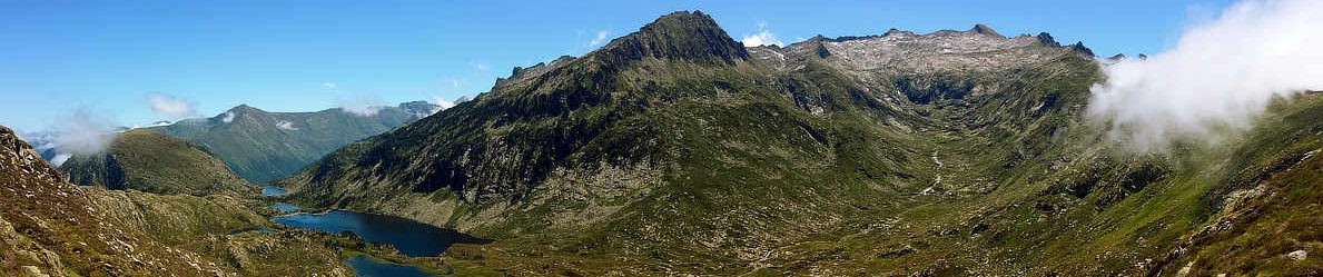
Last but not least, I have included many more photos than before, so that you can literally have a better picture of how splendid the trail and the Pyrenees are.
Detailed and comprehensive, yet clear-structured
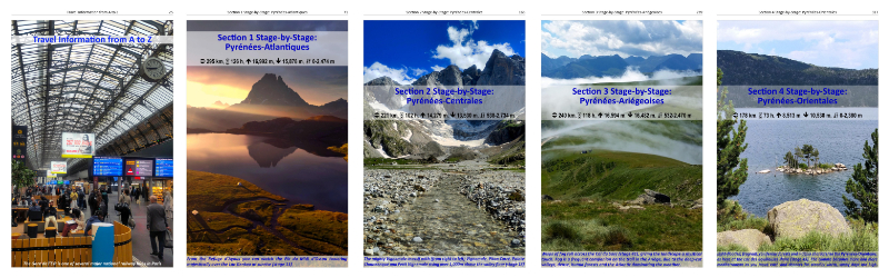
With its 388 pages, the book is comprehensive and offers lots of details not found in other GR10-guidebooks, yet is very clear-structured. Whether you plan to thruhike or just walk parts of the GR10, with my book you’ll be able to set out confidently with all needed information at your fingertips directly in each stage. No need to look up tables at the back end of the book for lodgings and services of a stage, as is the case in other GR10-guidebooks. In the general chapter “Travel Information from A to Z” with more than 40 pages, you find lots of additional detailed travel info.
The trail is now described stage by stage in 55 stages and, where applicable, with variants or alternatives for hikers with dogs or for bad weather situations. Each stage contains detailed descriptions of the trail, including alerts about poorly-marked parts or potentially dangerous or hazardous or difficult sections. As before, two additional chapters provide lodging information around the greater Hendaye (at the Atlantic) and Banyuls-sur-Mer (at the Mediterranean) regions.
Main features
Below are some of the main features of the e-book:
- The e-book can be used on any smartphone with the free Kindle-app, no separate device or e-book-reader needed;
- Once purchased and downloaded to your Kindle-app, you can read it offline on the trail and anywhere, no internet connection needed (put your phone in airplane mode and save battery);
- Each entry of the TOC (table of contents) can be addressed directly, since the detailed TOC is included as a menu item in the Kindle-app;
- You can set your own bookmarks in the Kindle-app for any page, so you can return to that page later quickly;
- You can do a full text search in the Kindle-app to find all occurrences of a search term, then navigate to the desired page with one click;
- You can swipe to flip back and forth between pages, and you can zoom and pan in each page with two fingers; if automatic rotation is activated on your smartphone, you can turn it sideways to auto-rotate the book for wider pages;
- Now includes detailed info for hikers with dogs, including variants for stages where dogs are not allowed (e.g. national parks and reserves) or variants where the regular route might not be suitable for a dog;
- The GPX-files for all stages (including variants) as described in the book can be downloaded free of additional charge by following the instructions given in the book; they include not only the tracks (including variants) and the numbered waypoints of each stage, but also many additional unnumbered waypoints and POIs in each stage (additional waterpoints, turns/forks, hazards, names of peaks, location of lodgings, etc.);
- Detailed info about lodgings, supply options and other services is included directly in each stage, no need to flip pages back and forth between a stage and the end of the book as in some other guidebooks; info provided includes name of the lodging/business, location, contact info, number of sleeping places, business periods, services provided and prices;
- Introductory sections provide useful information about population and culture, geography and geology, and flora and fauna;
- A dedicated section provides detailed travel information from A to Z, including useful topics such as public transportation, tourist information network, selected embassies and consulates, travel period, emergency telephone numbers, hiking maps, medical care, provisions and supplies, and many more;
- All numbered (and thus easily identifiable) waypoints mentioned in each stage’s text are also conveniently listed in the summary table at the beginning of each stage, including their distances and standardized walking times from the stage’s start, and also shown on the stage maps and elevation profiles; in addition, each stage starts with a brief general stage introduction text;
- Catchy symbols make it easy to find important information in the stage texts and maps at a glance;
- Where they exist, alternatives and variants (e.g., for bad weather or for hikers with dogs), or other important info, are described in highlighted sections directly in each stage;
- 72 coloured stage maps scale 1:150,000 (at least one in each stage, including variants);
- 58 stage elevation profiles (at least one in each stage, including variants);
- 2 coloured general overview maps and overview elevation profiles, one each for the west and east half of the trail;
- 4 separate introductory sections with coloured segment-overview maps, one at the beginning of each of the 4 distinct Pyrenees segments (Pyrénées-Atlantiques, Pyrénées-Centrales, Pyrénées-Ariégeoises, Pyrénées-Orientales);
- 2 coloured overview maps for the greater Hendaye (Atlantic coast) and Banyuls-sur-Mer (Mediterranean coast) regions;
- 248 colour photographs and illustrations;
- Appendix with keyword-index for easy finding of places and topics of interest;
- Appendix with “pocket dictionary” English-French with useful words and phrases grouped for various purposes (general, health, payments, food, lodging, on the trail, weather, numbers, time, calendar);
Makes a great gift — for yourself or others
If you are planning to hike the Pyrenees Trail GR10, then this guidebook is an invaluable resource. Not only will it be of great help when you’re out on the trail, but also when you’re preparing the details of your trip before you set off.
With everybody having a smartphone nowadays, it makes perfect sense to also have your hiking-guidebook with you as an e-book, if you don’t want to carry the additional weight of a printed book.
So don’t hesitate, go get it on Amazon and also let your hiking-enthusiast friends, family, relatives and coworkers all around the world know about it. Spread the word by forwarding this blogpost to others who might be looking for an excellent hiking-guidebook for the Pyrenees Trail GR10, or who might be looking for inspiration on where to go hiking next.
Thanks, and as always happy trails, or as the French say: “bon courage“
Fuat